![](/images/other/stat-length.png)
![Tocht Te voet Mladá Boleslav - CZ-3031 - Photo](https://media.geolcdn.com/t/1900/400/1cba082c-b08e-4727-af1f-b0e5b0f93ea2.jpeg&format=pjpeg&maxdim=2)
CZ-3031
SityTrail - itinéraires balisés pédestres
Tous les sentiers balisés d’Europe GUIDE+
![Lengte](/images/other/stat-length.png)
Lengte
4,5 km
![Max. hoogte](https://static1.geolcdn.com/siteimages/upload/files/1508320355ic_sort_altitude_max_24dp.png)
Max. hoogte
295 m
![Positief hoogteverschil](https://static1.geolcdn.com/siteimages/upload/files/1508320355ic_sort_den_pos_24dp.png)
Positief hoogteverschil
107 m
![Km-Effort](/images/other/stat-length.png)
Km-Effort
5,7 km
![Min. hoogte](https://static1.geolcdn.com/siteimages/upload/files/1508320355ic_sort_altitude_min_24dp.png)
Min. hoogte
213 m
![Negatief hoogteverschil](https://static1.geolcdn.com/siteimages/upload/files/1508320355ic_sort_den_neg_24dp.png)
Negatief hoogteverschil
43 m
![Boucle](https://static1.geolcdn.com/siteimages/upload/files/16400158638029165_repeat_loop_refresh_sync_direction_icon.png)
Boucle
Neen
Markering
Datum van aanmaak :
2025-02-06 22:08:49.91
Laatste wijziging :
2025-02-06 22:08:49.91
![Te voet](https://static1.geolcdn.com/sitytour/trail-icons/100.png)
1h17
Moeilijkheid : Gemakkelijk
![Scan deze QR-code om de tocht te openen in de SityTrail-applicatie](https://capi.geolives.com/qq0zvz2zws4bq2lad0pu/sitytour/trails/4344166/qr.png?size=200)
Gratisgps-wandelapplicatie
Over ons
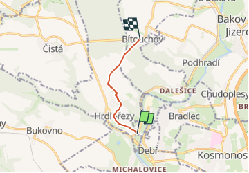
Tocht Te voet van 4,5 km beschikbaar op Centraal-Bohemen, Onbekend, Mladá Boleslav. Deze tocht wordt voorgesteld door SityTrail - itinéraires balisés pédestres.
Beschrijving
Tocht aangemaakt door cz:KČT.
Plaatsbepaling
Land:
Czech Republic
Regio :
Centraal-Bohemen
Departement/Provincie :
Onbekend
Gemeente :
Mladá Boleslav
Locatie:
Unknown
Vertrek:(Dec)
Vertrek:(UTM)
491974 ; 5588234 (33U) N.
Opmerkingen
Wandeltochten in de omgeving
![Tocht Te voet Bělá pod Bezdězem - Okružní Bělá p. B. - Valdštejnsko - Photo](https://media.geolcdn.com/t/375/260/2dbc0189-a80e-49e5-b256-7dee5247b0c6.jpeg&format=jpg&maxdim=2)
![Te voet Te voet](https://static1.geolcdn.com/sitytour/trail-icons/100.png)
Okružní Bělá p. B. - Valdštejnsko
Te voet
Gemakkelijk
Bělá pod Bezdězem,
Centraal-Bohemen,
Onbekend,
Czech Republic
![](/images/other/stat-length.png)
9,1 km | 10,8 km-effort
2h 26min
![](https://static1.geolcdn.com/siteimages/upload/files/16400158638029165_repeat_loop_refresh_sync_direction_icon.png)
Neen
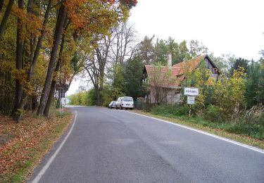
![Tocht Te voet Ralsko - [M] místní okruh - Photo](https://media.geolcdn.com/t/375/260/9d0bc935-9f2f-4659-bde0-51fc83ef0549.jpeg&format=jpg&maxdim=2)
![Te voet Te voet](https://static1.geolcdn.com/sitytour/trail-icons/100.png)
[M] místní okruh
Te voet
Gemakkelijk
Ralsko,
Noordoost,
Liberecký kraj,
Czech Republic
![](/images/other/stat-length.png)
16,5 km | 19,6 km-effort
4h 27min
![](https://static1.geolcdn.com/siteimages/upload/files/16400158638029165_repeat_loop_refresh_sync_direction_icon.png)
Ja
![Tocht Te voet Kněžmost - CZ-3086 - Photo](https://media.geolcdn.com/t/375/260/429050cd-2e54-478a-8056-0d9c77ac6993.jpeg&format=jpg&maxdim=2)
![Te voet Te voet](https://static1.geolcdn.com/sitytour/trail-icons/100.png)
CZ-3086
Te voet
Gemakkelijk
Kněžmost,
Centraal-Bohemen,
Onbekend,
Czech Republic
![](/images/other/stat-length.png)
6,9 km | 8,9 km-effort
2h 1min
![](https://static1.geolcdn.com/siteimages/upload/files/16400158638029165_repeat_loop_refresh_sync_direction_icon.png)
Neen
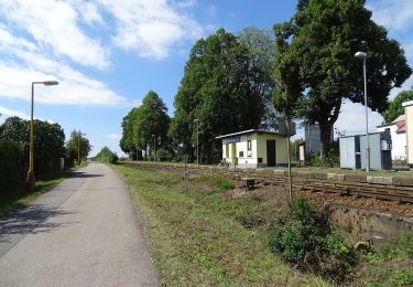
![Tocht Te voet Ralsko - [Č] místní okruh - Photo](https://media.geolcdn.com/t/375/260/e83de129-8b6a-4861-9e87-4042b4e33769.jpeg&format=jpg&maxdim=2)
![Te voet Te voet](https://static1.geolcdn.com/sitytour/trail-icons/100.png)
[Č] místní okruh
Te voet
Gemakkelijk
Ralsko,
Noordoost,
Liberecký kraj,
Czech Republic
![](/images/other/stat-length.png)
9,4 km | 11,4 km-effort
2h 35min
![](https://static1.geolcdn.com/siteimages/upload/files/16400158638029165_repeat_loop_refresh_sync_direction_icon.png)
Ja
![Tocht Te voet Mšeno - Cinibulkova naučná stezka - Photo](https://media.geolcdn.com/t/375/260/0c66d540-766b-4ff2-a713-238c95522d4f.jpeg&format=jpg&maxdim=2)
![Te voet Te voet](https://static1.geolcdn.com/sitytour/trail-icons/100.png)
Cinibulkova naučná stezka
Te voet
Gemakkelijk
Mšeno,
Centraal-Bohemen,
Onbekend,
Czech Republic
![](/images/other/stat-length.png)
8,4 km | 11,8 km-effort
2h 40min
![](https://static1.geolcdn.com/siteimages/upload/files/16400158638029165_repeat_loop_refresh_sync_direction_icon.png)
Ja
![Tocht Te voet Žďár - CZ-Březina - Příhrazy (modrá) - Photo](https://media.geolcdn.com/t/375/260/e4fcbe38-f88a-4c24-8281-6375a18288a8.jpeg&format=jpg&maxdim=2)
![Te voet Te voet](https://static1.geolcdn.com/sitytour/trail-icons/100.png)
CZ-Březina - Příhrazy (modrá)
Te voet
Gemakkelijk
Žďár,
Centraal-Bohemen,
Onbekend,
Czech Republic
![](/images/other/stat-length.png)
4,9 km | 6,3 km-effort
1h 25min
![](https://static1.geolcdn.com/siteimages/upload/files/16400158638029165_repeat_loop_refresh_sync_direction_icon.png)
Neen
![Tocht Te voet Loučeň - Naučná stezka Loučeň - Photo](https://media.geolcdn.com/t/375/260/c5532e45-a7ef-4a42-92b0-fb00e0a24a6b.jpeg&format=jpg&maxdim=2)
![Te voet Te voet](https://static1.geolcdn.com/sitytour/trail-icons/100.png)
Naučná stezka Loučeň
Te voet
Gemakkelijk
Loučeň,
Centraal-Bohemen,
Onbekend,
Czech Republic
![](/images/other/stat-length.png)
3,7 km | 4,3 km-effort
58min
![](https://static1.geolcdn.com/siteimages/upload/files/16400158638029165_repeat_loop_refresh_sync_direction_icon.png)
Neen
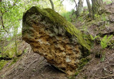
![Tocht Te voet Mšeno - [Č] Mšeno - U Grobiána - Photo](https://media.geolcdn.com/t/375/260/982ee8c5-03c7-4fca-841d-608ba78e558d.jpeg&format=jpg&maxdim=2)
![Te voet Te voet](https://static1.geolcdn.com/sitytour/trail-icons/100.png)
[Č] Mšeno - U Grobiána
Te voet
Gemakkelijk
Mšeno,
Centraal-Bohemen,
Onbekend,
Czech Republic
![](/images/other/stat-length.png)
5,7 km | 6,7 km-effort
1h 31min
![](https://static1.geolcdn.com/siteimages/upload/files/16400158638029165_repeat_loop_refresh_sync_direction_icon.png)
Neen
![Tocht Te voet Mšeno - CZ-1069 - Photo](https://media.geolcdn.com/t/375/260/345aa0c8-f66b-4a41-b4b3-61e4a13e3914.jpeg&format=jpg&maxdim=2)
![Te voet Te voet](https://static1.geolcdn.com/sitytour/trail-icons/100.png)
CZ-1069
Te voet
Gemakkelijk
Mšeno,
Centraal-Bohemen,
Onbekend,
Czech Republic
![](/images/other/stat-length.png)
12,8 km | 17,5 km-effort
3h 59min
![](https://static1.geolcdn.com/siteimages/upload/files/16400158638029165_repeat_loop_refresh_sync_direction_icon.png)
Neen